![]()
|
|
|
|
|
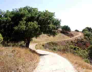
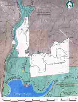
Climb Up, Look Down Neil Wiley It’s not a wilderness experience, but a walk up St. Joseph’s Hill is a nice way to spend a morning. To get there, drive north on Highway 17, then turn right on Alma Bridge Road (the last exit before Los Gatos). After passing the dam, watch for a large parking area on the right. (It costs $4.00 to park for the day. A machine accepts cash or credit card.) Almost directly across the road, you’ll find the trailhead to St. Joseph’s Hill. The first hundred yards are steep and rocky, but as you climb, the grade is less demanding. Jones Trail is not that tough for an old hiker, but it‘s enough to make most yuppie runners sweat. As one gasping runner told me, “I ate too much ice cream, I must punish myself.” Doesn’t that sound like the perfect mantra for Silicon Valley? To see the most of the park, I recommend turning right on Novitiate Trail, then right again on Manzanita Trail. This route gives you some good views of Lexington Reservoir and the Sierra Azul mountain range on the way up to 1250-foot high St. Joseph’s Hill. As you continue on Manzanita Trail, you loop around to the north, providing views of Los Gatos and Santa Clara Valley. Your loop continues down slope along Novitiate Trail to the intersection with Jones Trail. Here, you can turn left to go back down to your car, or turn right to walk toward Los Gatos. Turning right, you can follow Jones Trail for 3/10 of a mile, then turn left on Flume Trail. This is a narrower hiking-only trail perched high above Highway 17. It offers views with a different perspective of the highway, the Cats Restaurant, Los Gatos Creek Trail and the Los Gatos foothills. Flume Trail meets up again with Jones Trail in Novitiate Park. (The two trails parallel each other and the Los Gatos Creek Trail.) If you continue through the gates, you’ll be on Jones Road in Los Gatos. Turning right onto Jones Trail will take you up slope, across the hill and back down to the parking area. Sections of the Jones Trail follow the historic alignment of Jones Road, once the main connection between Los Gatos and the abandoned towns of Lexington and Alma. Before our recorded history, the native Ohlone people may have used this same route to reach acorn-bearing oaks and the ocean. The first recorded travel through the area was in 1791 by California mission builders. For more than a century, pack teams, wagons and stagecoaches used this steep and winding road to reach our Santa Cruz Mountains and beyond. Now, you can walk in their footsteps. Unlike then, heavy traffic, both human and vehicular, disturbs the peace. You’ll share the trail with many runners and mountain bicyclists. And from most places in the park, you’ll hear gravel trucks on Alma Bridge Road and the heavy traffic of Highway 17. I couldn’t find a convenient place to rest or picnic. Although Novitiate Park has one bench, there is nary a chair, table or hammock on St. Joseph’s Hill. Watch out for ankle-twisting rocks. And, yes, it seems like you walk uphill most of the time. I guess that’s why they call it a hill. But in spite of these minor inconveniences, few mountain walks afford so many scenic views in such a short distance. The entire Jones/Manzanita loop is less than three miles. The Flume/Jones trail loop adds 2.3 miles. A few tips. Mornings are cooler and provide more shade on the western slopes. Be sure to bring water. I saw no water fountains on the hill. Although lots of runners wear light shoes, ankle-protecting boots might be safer in the rocky areas. If the air looks clear, a pair of binoculars can help you enjoy the view. And, if you are like me, a little food wouldn’t hurt. A peanut butter sandwich is a suitable reward for conquering St. Joseph’s Hill. |
|
(c) 1997, 1998, 1999, 2000, 2001, 2002, 2003, 2004, 2005, 2006, 2007, 2008, 2009 mountain network news All rights reserved.
|